Area Boundaries and Map
Click photo to download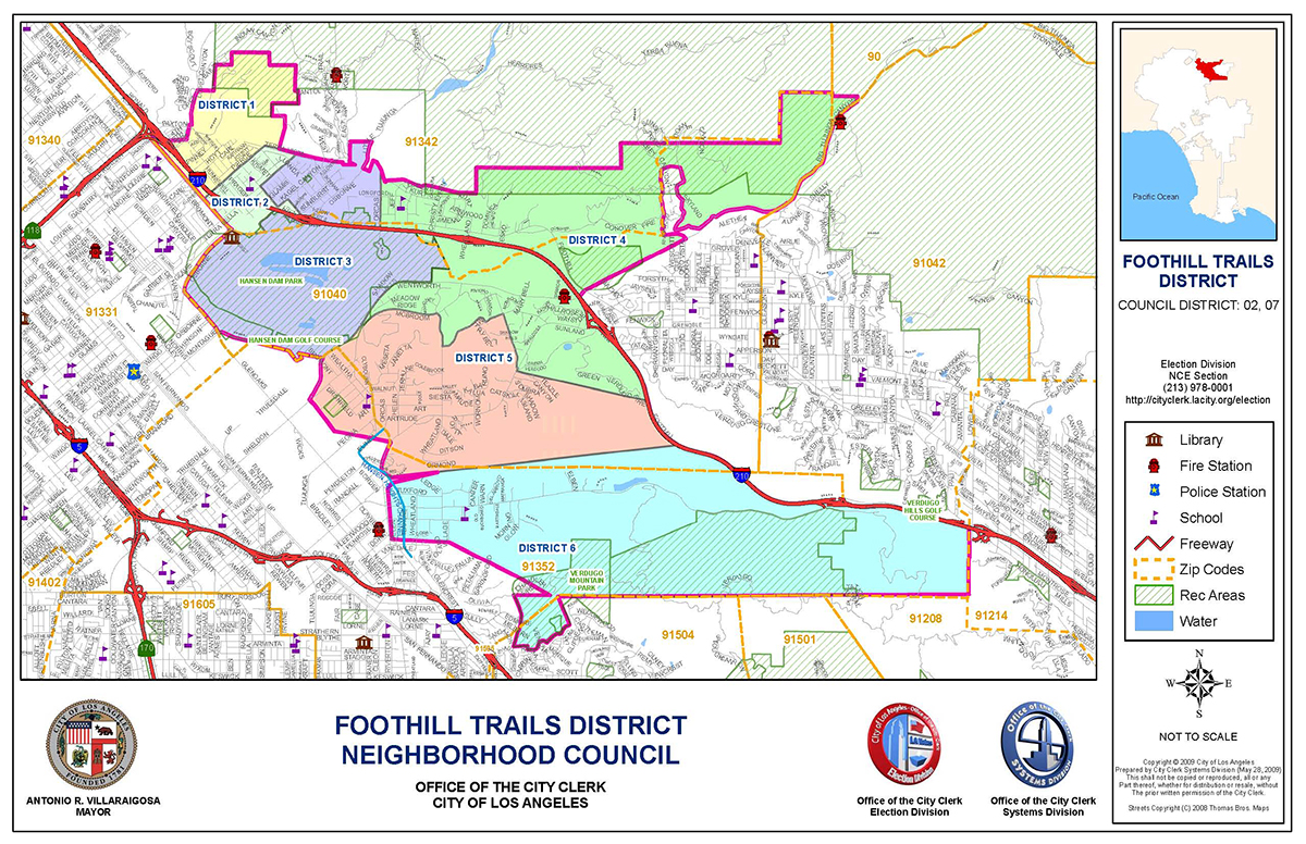
What are the Council’s Boundaries?
NORTH:
Begin at the N.E. Corner of the Los Angeles City/Los Angeles County border in Big Tujunga
Wash on the provided map.
Follow the city/county border WEST to Paxton St.
Go WEST on Paxton to Foothill Blvd.
WEST:
Go S.E. on Foothill to Osborne St.
Go S.W. on Osborne to Glenoaks Blvd.
Go S.E. on Glenoaks to Montegue St.
Go EAST along the southern border of Hansen Dam
Golf course to Wentworth St.
Go S.W. on Wentworth to Sheldon St.
Go S.E. (paralleling Glenoaks) past the southern tip of Stonehurst Rec Center, then
Go EAST across country to the intersection of Stonehurst St. and Sunland Blvd.
Go SOUTH on Sunland to Chivers St.
Go EAST in a straight line following the existing boundary of the Sun Valley Neighborhood
Council, then back West along their boundary until it intersects with the Hansen Heights
Channel (storm drain).
Go SOUTH behind the westward facing commercial properties on Sunland Blvd. to just
north of the south facing properties of Vinedale St.
Go EAST behind (north of) the south facing properties on Vinedale St. to the ridgeline
(a clear physical boundary) above Vinevalley Drive, then
Go S.E. Along the ridgeline to the N. E. (upper right) corner of the WESTERN half of
Verdugo Mountain Park
SOUTH:
Go counterclockwise around the western half of the park, then
Go EAST along the LA/Burbank border (cutting through the East half of the park) until
the border turns due NORTH.
EAST:
Go NORTH on the LA/Glendale city border to the 210 Freeway.
Go WEST on the 210 until it crosses Wentworth Blvd.
Go N.E. across country along the southern edge of the Big Tujunga wash to the joining of
Oro Vista Ave. and Big Tujunga Road.
Go due NORTH across Big Tujunga wash until reaching upper Oro Vista Ave.
Foothill Trails District Neighborhood Council – By Laws Page 4 of 14
Go due WEST to the furthest western point of Oro Vista Ave. Continue due WEST to the
southernmost point of Riverwood Drive.
Go due NORTH behind any western (east-facing) homes on Riverwood Drive. Continue
NORTH behind any western (east-facing) homes on Ebey
Canyon Road. Follow Ebey Canyon Road EAST (behind any south-facing homes) to Doane Canyon Road.
Go SOUTH on Doane Canyon Road to the end of the road, then continue SOUTH across
Big Tujunga wash to the intersection of Big Tujunga Road and Oro Vista Ave.
Go N.N.E. on Big Tujunga Canyon Road to the N.E. Corner of the Los Angeles City/Los Angeles
County border and the National Forest in Big Tujunga Wash on the provided map
where we began.
The boundaries may be adjusted in accordance with Article V of the Plan.
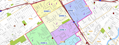
Area 1:
Starting where Paxton Street cross the city/county border.
SOUTHWEST to Foothill Blvd.
SOUTHEAST along Foothill to Pierce St.
NORTHEAST along Pierce to Van Nuys Blvd.
EAST along Van Nuys Blvd to city/county line,
WEST along city/county line to Lopez Canyon Rd.
Follow city/county line SOUTHWEST back to the starting point.
Area 2:
Starting at Pierce St. and Foothill Blvd.
NORTHEAST along Pierce St. to Van Nuys Blvd.
EAST along Van Nuys Blvd. and Terra Vista Way to Tierra Bella.
SOUTHWEST along Terra Bella to Fenton Ave.
SOUTHEAST along Fenton Ave. to Kagel Canyon.
NORTHEAST along Kagel Canyon to Kismet St.
SOUTHEAST along Kismet St. to Sunburst St.
SOUTHWEST along Sunburst St. to the 210 Freeway.
NORTHWEST along the 210 Freeway to Kagel Canyon Road
SOUTHWEST along Kagel Canyon Road to Gladstone St.
WEST along Foothill Blvd. to the starting point.
Area 3:
Starting where Paxton Street cross the city/county border.
SOUTHWEST to Foothill Blvd.
SOUTHEAST along Foothill to Pierce St.
NORTHEAST along Pierce to Van Nuys Blvd.
EAST along Van Nuys Blvd to city/county line,
WEST along city/county line to Lopez Canyon Rd.
Follow city/county line SOUTHWEST back to the starting point.
Area 4:
Starting at the city limit near the north end of Orcas St following the city limit NORTHEAST
to FTDNC border at Big Tujunga Road.
SOUTHEAST along Big Tujunga Rd. to Oro Vista (excluding all habitable areas north of Big
Tujunga Wash in Riverwood Ranch as described in FTDNC boundaries)
SOUTHWEST across country to 210 Freeway at Wentworth St.
SOUTHEAST along the 210 Freeway to the intersection of Green Verdugo Fire Road
WEST across country to the intersection of Teazle Canyon Road and Sunland Blvd
NORTH on Sunland Blvd to Johanna Ave
NORTHWEST along Johanna Ave. to La Canada Way.
WEST along La Canada Way to Wheatland Ave.
NORTH along Wheatland Ave. to McBroom St.
WEST along McBroom St. to Clyborn Ave.
NORTH to Wentworth St
NORTHEAST along Wentworth St. to the Western border of the Hansen Dam Basin
NORTH going counterclockwise around the Hansen Dam Basin to Orcas Street
so as to include all properties on Woldrich St.
NORTH along Orcas Street to the starting point.
Area 5:
Starting at the intersection of McBroom St. and Clyborn Ave
EAST along McBroom St to Wheatland Ave.
SOUTH along Wheatland Ave to La Canada Way
EAST along La Canada Way to Johanna Ave.
SOUTHEAST along Johanna Ave to Sunland Blvd.
SOUTHWEST along Sunland Blvd to Teazle Canyon Road
SOUTHEAST across country to the intersection of Green Verdugo Fire Road and the 210 Freeway
SOUTHWEST across country passing SOUTH of Ormond St and Sunland Park Drive until reaching Sunland
Blvd at the intersection of the Hansen Heights Flood Control Channel and Sunland Blvd.
NORTH along Sunland Blvd. to a point halfway between Chivers Ave. and Stonehurst St.
NORTHWEST passing SOUTH of Elinda Place and Stonehurst Recreation Center to the
intersection of Sheldon St. and Wentworth St.
NORTHEAST along Wentworth St to a point due north of Clyborn Ave.
SOUTH to the intersection of Clyborn Ave. and McBroom St.
SOUTHEAST along McBroom St. to the starting point.
Area 6:
Starting where the Foothill Freeway crosses the city line.
WEST and NORTHWEST onlong the Foothill Freeway to a point directly south of Oro Vista Road (in Sunland).
WEST cross country passing north of all properties on Elben St., Del Arroyo Dr., and Ledge Ave. and along the border of the Sun Valley Neighborhood council to the point where FTDNC border intersects with the Hansen Heights Channel (storm drain).
SOUTH behind the westward facing commercial properties on Sunland Blvd. to just north of the south facing properties of Vinedale St.
Upcoming Meetings & Events
Join Our Mailing List

Sign up here to receive meeting agendas.
Area Boundaries and Map
Want to know how your Neighborhood Council money is being spent?Click here, then select Foothill Trails District Neighborhood Council from dropdown menu.
For details, then click on "MER" (Monthly Expenditure Report).